Bucharest is the capital and largest city of Romania, as well as its cultural, industrial, and financial centre. It is located in the southeast of the country, on the banks of the Dâmbovița River, less than 60 km (37.3 mi) north of the Danube River and the Bulgarian border.
Bucharest's Ethnical and Religious Structure
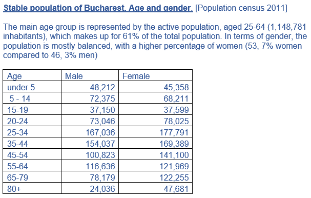
-Sybell Bucur-
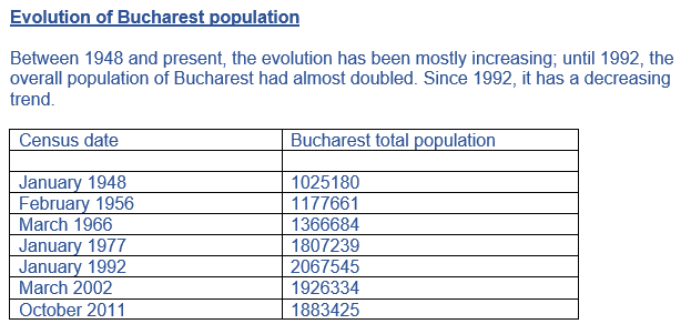
The city's population, according to the 2002 census, was 1,926,334 inhabitants, or 8.9% of the total population of Romania. Bucharest's population experienced two phases of rapid growth, the first beginning in the late 19th century when the city was consolidated as the national capital and lasting until the Second World War, and the second during the Ceaușescu years (1965–1989), when a massive urbanization campaign was launched and many people migrated from rural areas to the capital. At this time, due to Ceaușescu's decision to ban abortion and contraception, natural increase was also significant.

A huge amount of the city's citizens is Christian. The Romanian state officially recognizes 18 religions and denominations.
In terms of religious affiliation, 96.1% of the population is Romanian Orthodox, 1.2% is Roman Catholic, 0.5% is Muslim, and 0.4% is Romanian Greek Catholic. Despite this, only 18% of the population, of any religion, attends a place of worship once a week or more. The life expectancy of residents of Bucharest in 2003–2005 was 74.14 years, around two years higher than the Romanian average. Female life expectancy was 77.41 years, in comparison to 70.57 years for males.
In terms of religious affiliation, 96.1% of the population is Romanian Orthodox, 1.2% is Roman Catholic, 0.5% is Muslim, and 0.4% is Romanian Greek Catholic. Despite this, only 18% of the population, of any religion, attends a place of worship once a week or more. The life expectancy of residents of Bucharest in 2003–2005 was 74.14 years, around two years higher than the Romanian average. Female life expectancy was 77.41 years, in comparison to 70.57 years for males.

Data sources:
https://ro.wikipedia.org/wiki/Bucure%C8%99ti
http://bucurestiul.info/populatia-bucurestiului/
https://www.libertatea.ro/stiri/stiri-interne/recensamant-rezultatele-finale-afla-care-este-populatia-stabila-a-bucurestiului-899664
https://ro.wikipedia.org/wiki/Bucure%C8%99ti
http://bucurestiul.info/populatia-bucurestiului/
https://www.libertatea.ro/stiri/stiri-interne/recensamant-rezultatele-finale-afla-care-este-populatia-stabila-a-bucurestiului-899664
Bucharest's population evolution
- Vlad Botila-
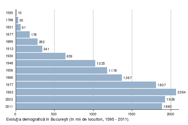 Evolution of the population of Bucharest,the numbers represent thousands of people who were living in Bucharest in that period.
As you can see,the maximum population was back in 1992(2.064.000 people).The reason was the desire of Nicolae Ceausescu,the president of Romania between 1974 and 1989,to have a huge urbanization and in that time industrialization was at its peak.
While in 1912 there were 341000 people in 1930 there were 639000.
While in 1912 there were 341000 people in 1930 there were 639000.

|
Facts about the population
Bucharest is a city of high population density: 9,994/km2 owing to the fact that most of the population lives in high-density communist era apartment blocks ,which were built during the 60’s and 70’s due to Nicolae Ceausescu’s desire to have a massive urbanization.So,from the 1966 to 1992 the population had increased from 1,366,684 to 2,064,474.In the recent times though,the population has decreased,now in Bucharest being 1,859 millions. The causes are: -the migration of the people to other countries,counties or outskirts of the city; -demographic aging; -low birth rates(between 1975 and 2014 the birth rate felt from 19.7 live births to one thousand inhabitants to 8.3 live births per thousand inhabitants -higher mortality rate. Also, Bucharest is among the top cities in the world with the highest population decline rate. |
A significant number of people commute to the city every day, mostly from the surrounding Ilfov County, but official statistics regarding their numbers do not exist.
In terms of religious affiliation, 96.1% of the population is Romanian Orthodox, 1.2% is Roman Catholic, 0.5% is Muslim, and 0.4% is Romanian Greek Catholic. Despite this, only 18% of the population, of any religion, attends a place of worship once a week or more.] The life expectancy of residents of Bucharest in 2003–2005 was 74.14 years, around two years higher than the Romanian average. Female life expectancy was 77.41 years, in comparison to 70.57 years for males.
Bucharest has a growing cultural scene, in fields including the visual arts, performing arts, and nightlife. Unlike other parts of Romania, such as the Black Sea coast or Transylvania, Bucharest's cultural scene has no defined style, and instead incorporates elements of Romanian and international culture.
The main reason is Unification of the Romanian Principalities,Moldova,Transilvania and Tara Romaneasca and Bucharest became the capital of the entire country.
Now we see that the population is starting to decrease,because of the migration in other countries or cities in Romania,higher mortality rate and demographic aging.
Bibliography:
http://www.mediafax.ro/economic/bucuresti-orasul-cu-una-dintre-cele-mai-mari-densitati-ale-populatiei-pe-kilometru-patrat-din-ue-16226789
https://ro.wikipedia.org/wiki/Bucure%C8%99ti
http://incont.stirileprotv.ro/.../orasele-care-isi-pierd-locuitorii-bucurestiul-in-top-20-localitati
http://enciclopediaromaniei.ro/wiki/Nicolae_Ceau%C5%9Fescu
http://www.miculparis.ro/orasul/statistici.html
The six sectors of Bucharest
-Matei Purcarea-
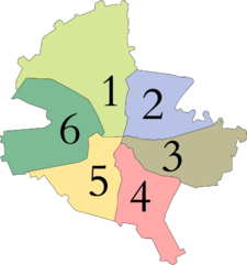
SECTOR 1
One of the 6 administrative units of Bucharest, Sector 1 is considered the wealthiest sector in Bucharest. Its quarters cover the northern part of the city and they include the well-known Baneasa, Dorobanti, Domenii, Floreasca, Pipera, Primaverii, Romana or Victoriei areas.
Sector 1 is limited in the south by Piata Nicolae Balcescu, in the south-west by the Dambovita River from the Elefterie bridge to Mircea Vulcanescu street and up to Calea Plevnei and all the way to the railway Bucuresti-Rosiori. At the north-west, it ends with the western outskirts of Tunari forest. The eastern border continues towards Vadul Moldovei street until it crosses the Bucuresti-Constanta railway; further on, the limit is set on the route that includes Calea Floreasca, Polona street, Pictor Verona street, C.A. Rosetti street up to Nicolae Balcescu Boulevard and ends at the crossroads with Carol Boulevard.
The area covered by sector 1 totals 67.5 km², being the largest sector in Bucharest.
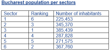
In terms of population, sector 1 had a total of 225,453 inhabitants as per October 2011 data, the lowest figure of the six sectors. It holds the same ranking in terms of density, with 3340 inhabitants/ km².
SECTOR 2
This sub-unit of Bucharest is situated in the North-Eastern part of Bucharest, between sector 1 and 3. Pantelimon, Colentina, Obor, Muncii are included in sector 2.
It starts at the crossroads between Republicii Boulevard and Nicolae Balcescu Boulevard, continues to CA Rosetti street all the way to Polona street and Calea Floreasca, further to the Bucharest-Constanta railway. At the north, the limit stretches to the Pantelimon railway station. Its eastern limit includes Lake Fundeni and Sos. Pantelimon, while the southern limit includes Sos Vergului, Piata Muncii, Calea Calarasi all the way to Hristo Botev Boulevard, Republicii Boulevard and Piata Nicolae Balcescu.
The area covered by sector 2 totals 32 km², being ranked the 5th of the 6 sectors in Bucharest in terms of size.
The population of sector 2 had a total of 345,370 inhabitants as per October 2011 data, the 3rd most populated sector in Bucharest. It has a density of 10,793 inhabitants/ km².
SECTOR 3
This is the most populous and most densely populated sub-unit of Bucharest; it includes Downtown Bucharest and other quarters like Titan, Vitan, Union Square, Dristor, Dudesti and the famous Old City.
At the north, its limit includes Republicii Boulevard up to Hristo Botev Boulevard, further to Negustori street, Calea Calarasi, Mihai Bravu, Muncii Boulevard to Pantelimon Sos and Colentina river. The eastern border starts with Peles street, Catelu railway station, till the border with Glina village. It follows the border of Catelu village up to Ion Sulea Boulevard and further to the Dambovita river. The southern limit stretches along the Dambovita river up to United Nations Square. At the west, its limit is Calea Victoriei until it meets Republicii Boulevard.
The area covered by sector 3 totals 34 km².
The population of sector 3 had a total of 385,439 inhabitants as per October 2011 data, the most populated sector in Bucharest. It has also the highest density, of 11,336 inhabitants/ km².
SECTOR 4
Sector 4 is situated in the southern part of Bucharest, starting from the center and it includes Giurgului, Berceni, Oltenitei, Tineretului and Vacaresti quarters.
Its northern limit starts with the Nations’ Square, following the Dambovita river towards Sos Vitan Barzesti; at the eastern border there is a conventional line towards south-west until the Cheile Turzii road up to Sos Berceni, including the Berceni cemetery. In the south, there is the ringroad going towards the south-western border that continues with Drumul Bercenarului up to Soseaua Giurgiului, where the western limit starts. It comprises Soseaua Giurgiului, Cutitu de Argint street, down to Mitropolitul Filaret street, Antim Street and all the way back to United Nations Square.
The area covered by sector 4 totals 34 km², the same as sector 3.
The population of sector 4 had a total of 287,828 inhabitants as per October 2011 data and a density of 8466 inhabitants/ km².
SECTOR 5
In between sectors 4 and 6, in the south, south-western part of Bucharest lies sector 5, including 13 Septembrie, Cotroceni, Giurgiului, Ferentari and Rahova quarters.
Its delimitation starts with the crossroads between Queen Elisabeta Bdv and Calea Victoriei. In the east, the border includes Calea Victoriei to United Nations’ Square, Apolodor street to George Georgescu street, across Libertatii Bdv, Calea Rahovei to Mitropolit Filaret street, Fabrica de Chibrituri, Cutitul de Argint street to Calea Serban Voda and Sos. Giurgiului. In the south eastern part, it start from the railway Bucuresti-Giurgiu, Sos Giurgiului to Orsova street up to Bucuresti- Magurele road. To the north there is Brasov street to Bd Ghencea and up to Drumul Sarii, Geniului Bdv, Sos Cotroceni and to the Dambovita river up to Elefterie bridge and to the United Nations’ Square.
The area covered by sector 5 totals 30 km², being the smallest of Bucharest sectors.
The population of sector 5 had a total of 271,575 inhabitants as per October 2011 data and a density of 9053 inhabitants/ km².
SECTOR 6
In the western part of Bucharest, sector 6 is situated between sector 5 and sector 1 and it includes quarters such as Crangasi, Drumul Taberei, Ghencea, Giulesti, Militari and Regie.
It starts where Dambovita meets Constantin Noica street and Sos Cotroceni; the eastern border includes Geniului Bdv, Drumul Sarii up to Ghencea Bdv. In the south, it reaches Intrarea Floarea Galbena (Yellow Flower). In the west, it goes up to Bdv Timisoara, towards the west until the ringroad railway to Arges channel then it follows Dambovita to Drumul Morii; to the north, it follows Calea Giulesti across Sos Orhideelor to Calea Plevnei and back to the Dambovita river.
The area covered by sector 6 totals 38 km².
The population of sector 6 had a total of 367,760 inhabitants as per October 2011 data, being the second most populous sector, and a density of 9678 inhabitants/ km².
One of the 6 administrative units of Bucharest, Sector 1 is considered the wealthiest sector in Bucharest. Its quarters cover the northern part of the city and they include the well-known Baneasa, Dorobanti, Domenii, Floreasca, Pipera, Primaverii, Romana or Victoriei areas.
Sector 1 is limited in the south by Piata Nicolae Balcescu, in the south-west by the Dambovita River from the Elefterie bridge to Mircea Vulcanescu street and up to Calea Plevnei and all the way to the railway Bucuresti-Rosiori. At the north-west, it ends with the western outskirts of Tunari forest. The eastern border continues towards Vadul Moldovei street until it crosses the Bucuresti-Constanta railway; further on, the limit is set on the route that includes Calea Floreasca, Polona street, Pictor Verona street, C.A. Rosetti street up to Nicolae Balcescu Boulevard and ends at the crossroads with Carol Boulevard.
The area covered by sector 1 totals 67.5 km², being the largest sector in Bucharest.
In terms of population, sector 1 had a total of 225,453 inhabitants as per October 2011 data, the lowest figure of the six sectors. It holds the same ranking in terms of density, with 3340 inhabitants/ km².
SECTOR 2
This sub-unit of Bucharest is situated in the North-Eastern part of Bucharest, between sector 1 and 3. Pantelimon, Colentina, Obor, Muncii are included in sector 2.
It starts at the crossroads between Republicii Boulevard and Nicolae Balcescu Boulevard, continues to CA Rosetti street all the way to Polona street and Calea Floreasca, further to the Bucharest-Constanta railway. At the north, the limit stretches to the Pantelimon railway station. Its eastern limit includes Lake Fundeni and Sos. Pantelimon, while the southern limit includes Sos Vergului, Piata Muncii, Calea Calarasi all the way to Hristo Botev Boulevard, Republicii Boulevard and Piata Nicolae Balcescu.
The area covered by sector 2 totals 32 km², being ranked the 5th of the 6 sectors in Bucharest in terms of size.
The population of sector 2 had a total of 345,370 inhabitants as per October 2011 data, the 3rd most populated sector in Bucharest. It has a density of 10,793 inhabitants/ km².
SECTOR 3
This is the most populous and most densely populated sub-unit of Bucharest; it includes Downtown Bucharest and other quarters like Titan, Vitan, Union Square, Dristor, Dudesti and the famous Old City.
At the north, its limit includes Republicii Boulevard up to Hristo Botev Boulevard, further to Negustori street, Calea Calarasi, Mihai Bravu, Muncii Boulevard to Pantelimon Sos and Colentina river. The eastern border starts with Peles street, Catelu railway station, till the border with Glina village. It follows the border of Catelu village up to Ion Sulea Boulevard and further to the Dambovita river. The southern limit stretches along the Dambovita river up to United Nations Square. At the west, its limit is Calea Victoriei until it meets Republicii Boulevard.
The area covered by sector 3 totals 34 km².
The population of sector 3 had a total of 385,439 inhabitants as per October 2011 data, the most populated sector in Bucharest. It has also the highest density, of 11,336 inhabitants/ km².
SECTOR 4
Sector 4 is situated in the southern part of Bucharest, starting from the center and it includes Giurgului, Berceni, Oltenitei, Tineretului and Vacaresti quarters.
Its northern limit starts with the Nations’ Square, following the Dambovita river towards Sos Vitan Barzesti; at the eastern border there is a conventional line towards south-west until the Cheile Turzii road up to Sos Berceni, including the Berceni cemetery. In the south, there is the ringroad going towards the south-western border that continues with Drumul Bercenarului up to Soseaua Giurgiului, where the western limit starts. It comprises Soseaua Giurgiului, Cutitu de Argint street, down to Mitropolitul Filaret street, Antim Street and all the way back to United Nations Square.
The area covered by sector 4 totals 34 km², the same as sector 3.
The population of sector 4 had a total of 287,828 inhabitants as per October 2011 data and a density of 8466 inhabitants/ km².
SECTOR 5
In between sectors 4 and 6, in the south, south-western part of Bucharest lies sector 5, including 13 Septembrie, Cotroceni, Giurgiului, Ferentari and Rahova quarters.
Its delimitation starts with the crossroads between Queen Elisabeta Bdv and Calea Victoriei. In the east, the border includes Calea Victoriei to United Nations’ Square, Apolodor street to George Georgescu street, across Libertatii Bdv, Calea Rahovei to Mitropolit Filaret street, Fabrica de Chibrituri, Cutitul de Argint street to Calea Serban Voda and Sos. Giurgiului. In the south eastern part, it start from the railway Bucuresti-Giurgiu, Sos Giurgiului to Orsova street up to Bucuresti- Magurele road. To the north there is Brasov street to Bd Ghencea and up to Drumul Sarii, Geniului Bdv, Sos Cotroceni and to the Dambovita river up to Elefterie bridge and to the United Nations’ Square.
The area covered by sector 5 totals 30 km², being the smallest of Bucharest sectors.
The population of sector 5 had a total of 271,575 inhabitants as per October 2011 data and a density of 9053 inhabitants/ km².
SECTOR 6
In the western part of Bucharest, sector 6 is situated between sector 5 and sector 1 and it includes quarters such as Crangasi, Drumul Taberei, Ghencea, Giulesti, Militari and Regie.
It starts where Dambovita meets Constantin Noica street and Sos Cotroceni; the eastern border includes Geniului Bdv, Drumul Sarii up to Ghencea Bdv. In the south, it reaches Intrarea Floarea Galbena (Yellow Flower). In the west, it goes up to Bdv Timisoara, towards the west until the ringroad railway to Arges channel then it follows Dambovita to Drumul Morii; to the north, it follows Calea Giulesti across Sos Orhideelor to Calea Plevnei and back to the Dambovita river.
The area covered by sector 6 totals 38 km².
The population of sector 6 had a total of 367,760 inhabitants as per October 2011 data, being the second most populous sector, and a density of 9678 inhabitants/ km².
Bibliography:
websites of the Bucharest sector City Halls:
www.primariasector1.ro
www.ps2.ro
www.primarie3.ro
www.ps4.ro
www.sector5.ro
www.primarie6.ro
www.metropotam.ro
www.wikipedia.ro
websites of the Bucharest sector City Halls:
www.primariasector1.ro
www.ps2.ro
www.primarie3.ro
www.ps4.ro
www.sector5.ro
www.primarie6.ro
www.metropotam.ro
www.wikipedia.ro
